With relief shading, the map is drawn as a 3D model, with lighting from the east or west. The effect is to greatly enhance the perception of the landscape, especially when you stand back and look at the map from a distance. There are no perspective effects, so the shaded map can be used for measurements exactly like a normal map. The only disadvantage is that some of the detail in the darker areas of the map is harder to read.
The Relief Settings dialog (accessed by clicking the Settings button next to the Relief shading option in either the Print dialog, or the Image export dialog) is shown below.
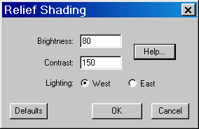
The Brightness controls the overall brightness of the image. The default value is 80%. This means that a horizontal area of the terrain is drawn slightly darker than normal, which gives a better highlight the brighter parts of the image. If you set the brightness to 100, the flat areas are drawn with normal brightness (ie, a flat white area still appears white).
The Contrast sets the variation between east and west facing slopes. Increasing the value gives a more dramatic effect, reducing it gives a more subtle effect. The default is 150. The contrast is automatically scaled by the maximum slope in the image. A contrast setting of 100% causes the point of maximum slope to be drawn as black. If your scene includes abrupt cliffs, increase the contrast to bring out the terrain features in the flatter areas. A value of zero removes the shading completely.
Occasionally, the landscape may appear to you to be "inside out" (ie, the valleys appear closer to you than the hills.) This is simply an optical illusion, not a problem with the software! Changing the direction of lighting from West to East or vice versa will make it pop back the other way.