You can import overlay data from an Shapefile, as follows:
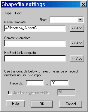
Click Overlay / Import, in the "Files of Type" control, select "Shapefiles (*.shp)" and browse in the file you want to load. Before loading the file, the Shapefile settings dialog (below) is displayed.

The "Name template" controls how the overlay objects are named, using data from the Shapefile's accompanying DBF file. The Fields pop-down list contains the field names from the database. Clicking the Add button adds the field to the end of the name. Fields are surrounded by %. There are two special fields: Filename is the name of the Shapefile, and Index is the record number in the Shapefile. You can edit the template to add other text or re-arrange the fields.
The Comment template and the HotSpot template control the comment text and HotSpot link for imported marks, in the same way. These are disabled if you are importing a track.
If your shapefile contains a large number of records, you may want to limit the import to a given range. Use the Records controls to set the range. By default, it imports all records. There is no set maximum, but the software may be unusable due to very long redraw times if you load too many overlays.
If you are loading a Polyline, you have the option to automatically join up sections. Where the endpoints are within the given threshold (in meters), the lines are joined up into a single track.
If you want to import a Route, simply import the polyline or polygon from the Shapefile as a track, then use the Convert to Route function in the pop-up menu for the Track.
If you have a *.prj file accompanying the shapefile, it is used to get the projection information. If not, a Projection dialog is opened that allows you to specify the projection parameters. If you don't know what to use, try either Lat/Long, or UTM Grid for the zone you are in.
To output a Shapefile, first setup the overlays using Show All... and Hide All... so that only the objects you want to export are visible. Then click Overlay / Export Visible. Select Files of Type: Shapefiles (*.shp) and give the file a name.
If the visible objects are all of the same type, the appropriate style of shapefile is generated as follows:
|
Overlay Object |
Shapefile type |
|
Route, closed (ie, the last waypoint the same as the first) |
Polygon |
|
Route, not closed |
Arcs |
|
Track, closed (ie, the "Closed" checkbox set in the Track properties |
Polygon |
|
Track, not closed |
Arcs |
|
Mark |
Points |
If the set of objects that you selected is a mixture of the above, then a dialog is displayed that allows you to select what is output. The output contains only those objects that match the criteria above.