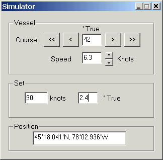
The GPS Simulator allows you to manually enter your position, speed, heading and the set (tide/current or, for aircraft, wind) speed and direction.
The position is displayed on the map, and all other features operate as if a real GPS were connected.
Click GPS / Setup, and select Simulator from the list in the Manufacturer control. All the other controls are grayed out.
Enter your starting position (tip: Click the New Mark toolbar button, double-click on the map to place the mark and open it's properties. Highlight the mark's position in the properties dialog and right-click / Copy. Click in the simulator's position control and right-click / Paste). The GPS position icon should appear on the map.
Enter your heading and speed, and the tidal set, if desired.
The < and > buttons adjust the heading by one degree in the indicated direction. The << and >> buttons adjust by 10 degrees. You can also use the left and right cursor keys to adjust the course (except when the keyboard focus is in one of the text controls).
Use the up/down buttons to adjust the speed, in 0.2 knot increments. Use the up and down cursor keys may also be used.
You can minimize the window, and the simulation continues with the selected settings.
If you close the window, the simulation is stopped. Click GPS / Setup again to restart it.
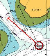 When using the simulator, the GPS position icons shows the heading/boatspeed vector as a thin black arrow, in addition to the course and speed over the ground. This allows you to visualize the tide/current set as the difference between the two arrows.
To display the heading in real life, you can connect the computer to the boat's integrated NMEA 0183 instrumentation system. The heading is obtained from the HDT or VHW sentence, and boat speed from VHW.