|
Auto-Routing
The app is able to use an on-line service to find the optimum route for driving, cycling or walking between two points, using roads and trail data.
This could be used to find the quickest driving route by road to your destination. However, Memory-Map is for off-road use, and the user interface is not intended to be used while driving. This is not an attempt to replace Google Maps!
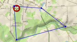
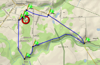
Suppose you are planning a bike ride along some winding roads, and you want to know the total distance of your ride, and to navigate some intricate turns along the way. First, manually plot the approximate route, (see Using Routes) using just a few waypoints. Then tap one of the waypoints and tap the Menu button, then Route Operations, Optimize Route, For Cycling. The app will add intermediate waypoints to direct you along roads and cycle paths. If the result is not what you want, use the Revert menu command to put it back to the original.


Tips for using routes
Tapping on any waypoint will display the total length of the route near the top of the screen.
Tap the menu button or right-click and Follow Route.
With your phone in a secure mount on your handlebars, you can use the Main Menu, Settings, Display Settings, Keep Screen On. Your phone will then remain on without interaction while Memory-Map is running (this will, however, drain the battery faster).
Then, enjoy your ride!
Notes
The Route Optimization is an online service that is only available while you are connected to the internet. You may incur mobile data transfer costs.
The service has limited knowledge of hiking and cycling trails, and it may not be able to place the route where you expect.
It is designed to find the fastest route, which may not be the more challenging, or the more scenic, route that you want to take. You can use intermediate waypoints to direct it along the scenic route.
Using routes with a large number of points may degrade the performance of your phone and run down your battery faster than normal.
Next: Alarms
|