The Data Display windows are to provide you with navigation information to guide you while your position is being tracked from a GPS input.
To open the Position Data window, click the GPS / Current Position menu command. A small window appears showing your course and speed, averaged course and speed, altitude and position.
You can click and drag to re-position the window on the screen.
To make the text larger or smaller, resize the window by clicking and dragging the bottom right corner.
Close the window by clicking the top right corner.
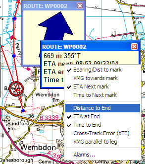
You can select which data are displayed by right-clicking in the window and clicking the items in the popup menu.
The Navigation Data window shows your position relative to a mark or route.
Create a mark, right-click on it and select Goto mark. The Navigation window appears, showing the name of the mark (which you can change by double-clicking the mark), and the distance and bearing from your current position. If you are moving, it also shows an arrow indicating the direction of the mark relative to your current direction of travel, the VMG and ETA.
The VMG (velocity made good) is the speed towards the mark.
The ETA (estimated time of arrival) is an estimate of the time you will arrive at the mark, assuming you maintain the current average speed. The speed is averaged over the last two minutes.
Time to Next mark displays the estimated elapsed time (hh:mm).
To navigate along a route, right click on the route, and select Follow Route. The Navigation window shows name of the route, with distance, bearing and relative direction to the next waypoint.
When navigating on a route, some additional data fields are available. Distance, time and ETA to end are self-explanatory.
The XTE (cross-track error) is your perpendicular distance from the line of the route. The arrows indicate the direction you should move to get closer to the line.
The VMG parallel to leg is the component of your velocity in the direction of the leg. This is useful for sailing, where you can set up a route in the direction of the wind (say the windward and leeward marks of a race course). The VMG parallel to leg then gives you a good estimate of your VMG to windward, and is not affected by your position on the course.
The software selects the waypoint based on which leg of the route is closest. It does not know any rules about rounding marks in a particular order, so when racing, you may find it displays the wrong waypoint. In this case, you will have to Goto the Waypoint, instead of Following the Route.
The Alarms dialog allows you to make the computer beep when you are approaching a waypoint (to alert you to an upcoming turn), and when you drift too far from the route.
You can reposition, resize and close the navigation window in the same way as the position data window. Again, right-clicking allows you to turn on or off each data item. Making the window larger increases the size of the text, allowing you to read it from some distance from the computer.